
June 2017
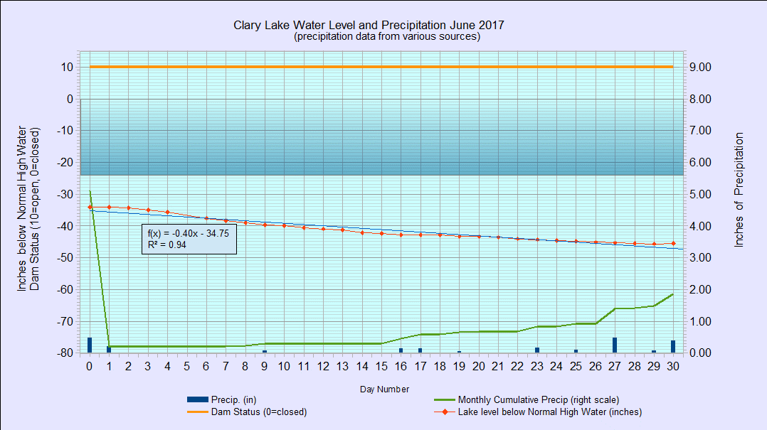
I have archived the June 2017 Water Level Chart (at left). The most notable feature of the June chart is the slow steady decline in the water level on the one hand, and how little the lake level actually fell over the course of the month. The water level fell or remained unchanged every day except the last day of the month when it rose a small fraction as the result of 0.46″ of rain received. That said, the lake only lost a total of 11.4″ in 30 days for an average drop of 0.38″ per day. With the lake at this general level, with the gate wide open, and with so little rain having fallen, I would have expected the lake to have dropped more like 22″ to 24″ over the course of the month- twice as much as it actually fell. I am at a loss to explain this except to speculate that either a) there was considerably less water leaving the lake than expected or b) there was a lot more water entering the lake than expected or c) a combination of both a and b. This bears investigation.
The rate at which the lake level falls when the dam’s gate is wide open and runoff is at a minimum varies with the water level. Here is a table you’ve seen a few times showing the relationship of lake level to rate of fall:
| Lake level in inches below top of dam | Rate of fall in inches in 24 hours |
|---|---|
| 0" to 36" | 1" |
| 36" to 48" | 3/4" |
| 48" to 62" | 1/2" |
| Below 62" | 1/4" or less |
So you see, the lake should have dropped about 3/4″ per day but in fact it only fell about half that amount. This turned out to be extremely fortuitous for our nesting loons as they were able to successfully incubate their eggs without having their nest stranded too far from the water.
We received only 1.87″ of rain in June which is considerably less than normal (3.74″) however we’ve received 18.02″ of rain to date which is about 3/4″ more than average.