Category Archives: Lake Environment

46th Annual Maine Lakes Conference Coming Up June 25th

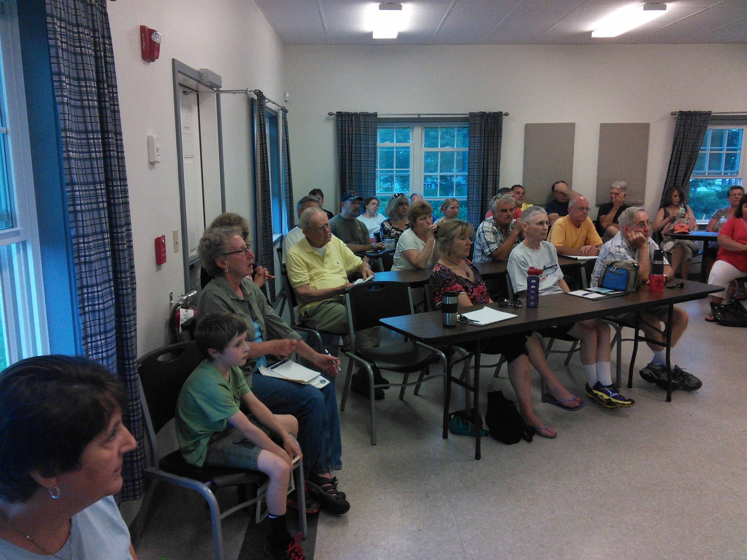
The Maine Lakes Society (formerly the Congress of Lake Associations or COLA) is holding their Annual Maine Lakes Conference on the 25th of this month. The itinerary, as usual, looks excellent. The Clary Lake Association is a long-time member of the Maine Lakes Society. For years the annual COLA conference was attended by Association Member Ed Grant. I’ve made a point of going in recent years and I always learn something new. I’ll be going to this one. The cost is $35 which includes lunch.

Here’s the email notice I received about this event:


We invite you to join us at the 46th Annual Maine Lakes Conference on Saturday, June 25th, at the Unity College Center for the Performing Arts! 

Keynote Speaker Holly Ewing of Bates College

This year we look to the future of Maine lakes monitoring and protection, and the myriad ways citizens can get involved in lake protection.  Our Keynote Speaker, Holly Ewing of Bates College, will introduce us to the latest research on  Gloeotrichia echinulata blooms and GLEON, the Global Lake Ecological Observatory Network, which is helping scientists and citizens alike better understand and communicate the way lakes are responding to our changing climate. Afternoon workshops on citizen science, lake and fisheries restoration, the latest on LakeSmart, new partnerships with Maine Audubon’s Stream Smart and LoonSmart programs, translating science in your outreach products, and hands on workshops offer diverse learning experiences at a great new venue in Unity, Maine.


 Additional Workshops include:
  • Cyanotoxins and Maine’s developing Public Alert System for Harmful Algal Blooms
  • What’s that stuff in the water? The appearance of metaphyton and other algae in our lakes and ponds
  • Long term, statewide collaborative lake monitoring efforts 
  • Special guest Friends of Lake Winnecook
  • The latest “Get Smart” tips from LakeSmart and Stream Smart
  • Hands on instruction with lake monitoring technology
  • Our new partnership with Maine Audubon’s LoonSmart Program
  • Creative tools for translating water quality data into meaningful communications
  • Lake and fisheries restoration efforts
  • Nature Journaling ~  Fish Identification  ~   Art Exhibit
  • Lunchtime breakouts: Council of Lake Associations Annual Roundtable, Camp Care, and Invasive Plant Monitoring FAQ’s
The annual conference will be at the fabulous Unity College Center for the Performing Arts nearLake Winnecook in Unity, Maine. Keep an eye on our Facebook page and website for more information on presentations and speakers. We are also still welcoming conference sponsors!
We hope to see you there!
 
 
Cheryl Daigle
&
Maggie Shannon
Executive Director
 
Program Director, LakeSmart & Policy
Maine Lakes Society
P O Box 447
Belgrade Lakes, Maine 04918

207-495-2301

04 June 2016: Early Summer Clary Lake Water Quality Update

current_tp_5-20-2016

Clary Lake Total Phosphorus

And it’s not good news. We’ve received the results back on our first Total Phosphorus (TP) sample for 2016, taken last month on May 20th. At 22 μg/L (micrograms per liter), TP is up at levels typically not seen until mid to late summer. The chart at left has been updated to include this latest data point, you can see where it plots up: it’s the first (only) dot in 2016, furthest to the right. We usually take 3 [the_tooltip text=”core” tooltip=”a sample of the whole water column from the surface down to 7 meters” url=”” background=”” color=””] samples of lake water each season for Phosphorus testing, and send them off to the State Lab for analysis. In the early spring, TP values on the order of 14 to 18 μg/L are more “normal” (for some value of the term “normal”) though in recent years they have been trending higher. Last spring on April 30th TP was 14 μg/L and 17 μg/L on April 25th the year before that. TP values above 18 μg/L typically mean an algae bloom is on the way. This does not bode well for water quality this coming summer.

Phosphorus is the primary nutrient responsible for algae growth in lakes. It comes from various sources including runoff containing eroded soil and sediments. Under conditions of low dissolved oxygen it can be released from bottom sediments in the lake. Wave action on exposed bottom sediments can also result in Phosphorus being released into the lake. Low water conditions resulting in exposed bottom sediments and reduced lake volume certainly contribute to higher Phosphorus concentrations.

David Hodsdon, Jack Holland and I went out yesterday morning for our regular biweekly water quality monitoring session. The transparency of the lake water has already dropped from 4.1 meters to 3.65 meters since May 20th . Data collected back through 2012 is available on the Clary Lake Water Quality Data page. Data back to 1975 is available upon request.

21 May 2016: Clary Lake Water Quality Monitoring Resumes for 2016

IMG_20160520_084140 (Custom)On Friday May 20th David Hodsdon and I (Jack Holland was not able to join us) were finally able to resume Clary Lake Water quality monitoring for 2016 albeit a month later than we had planned, but still within the allowable time frame. Better late than never as the saying goes. We had originally planned on starting a month ago, but our YSI Pro 20 digital dissolved oxygen meter which the Association purchased through donations a few years ago failed to pass routine calibration which is performed each spring by Maine VLMP technicians. They first thought the problem was a bad probe but swapping it out for a known-good probe didn’t solve the problem. YSI Technical Support suggested it might be water in the cable connector housing so they let the unit sit around disassembled for a few days to dry out. After that it started working intermittently. They ran some more tests on it over the next week finally certified it for use with the instructions to “keep an eye on it.” We got it back midweek last week.

This first time out, the DO meter worked flawlessly (and we hope it continues). With a secchi disk reading of 4.1 meters (13.25′) the water clarity is excellent, and about normal for this time of year. But be warned: it’s early in the season yet, and the water quality can and will deteriorate. The lake has yet to “stratify” meaning that it is pretty homogenous (well mixed) and there is no thermocline yet: the temperature from the surface to the bottom only varied 2.5° Celsius. This means that if you were to go swimming now you’d think the whole lake was cold, not just 6′ down like during the summer. Likewise, the dissolved oxygen reading only varied 2.6 mg/l from surface down to 7 meters. Continue reading

21 May 2016: Clary Lake Dam’s Gate Almost But Not Quite Closed

IMG_20160521_094122 (Custom)Late last Thursday afternoon for reasons known only to himself, the Clary Lake dam owner closed the dam’s gate to within about 7″ of completely shut. As you can see from the picture at left, there’s still quite a bit of water flowing out of the lake but the mill pond behind the dam has considerably more water in it than when the gate was wide open. However, while the water may be backing up behind the dam, the lake level is still falling about 1/4″ per day. Remember, water only flows down hill and there is a mile and a half of meandering channel down which the water has to flow to get from the lake to the dam. With the gate wide open and the lake this low, I suspect the water level right at the dam itself has been as much as 2 feet lower than out on the lake, perhaps even more. I’ve actually measured a 3″ difference when gate was wide open and the lake was almost full. Albert Boynton whose family owned the dam in the 1920’s and who was actually born in the little red house on the dam told me once that after a morning of sawing lumber, the upper mill pond would have fallen considerably; when they returned from dinner, it would be full again.

Continue reading

05 May 2016: Black Crappies firmly established in Clary Lake

IMG_20160504_134717

Black Crappie

Well, we knew that. We’ve known for a while now that Black Crappies were being caught in Clary Lake, and I’ve written about before (see: 28 May 2015: A Black Crappie caught in Clary Lake) but I had not actually caught one myself until yesterday when I hooked this 11″ specimen. Unlike the bass that I catch, I kept this one and had it for dinner last night. It was not bad.

Black Crappie are firmly established in most waterways in other parts of the country, especially down south (in Louisiana they’re called “Sac-a-Lait”) and they are generally considered to be an excellent pan fish, good eating with firm white flesh. However, here in Maine they are considered an invasive species and they are not native to Clary Lake (for that matter, neither are large and small mouth bass which were introduced in the late 1960’s and early 1970’s). Apparently sometime in the last 10-15 years someone introduced them into Clary to “improve” the fishery. It’s clear from the size of this one that we’ve got a firmly established breeding population of Black Crappie in Clary Lake.

I sent a picture of the fish I caught to Jason Seiders, a fisheries biologist with the Department of Inland Fisheries and Wildlife and he responded that his staff will be conducting surveys of the Sheepscot River drainage this summer, focused mainly on assessing bass populations and confirming the presence of black crappie. Black Crappie are a very prolific fish and they can pretty much take over a water body. It is believed that they will likely affect Clary’s small mouth bass population the most.

Jason Seider’s final advice: don’t be afraid to keep all the Crappie you catch. For what it’s worth, I caught this one on a 6″ rubber worm but I expect you’ll be able to catch them on about anything you throw in the water.

09 April 2016 BDN: What an early spring means for Maine’s lakes

campic1-3-11-2016

Clary Ice Out

You’ll recall that the ice went out on Clary Lake on March 13th this year, the earliest since we started keeping records in 2001. Well there’s a great article in today’s Bangor Daily News about the potential impact of an early spring on lake water quality. Basically, warmer than usual weather coupled with an early ice-out result in water temperatures rising higher, sooner, and lake stratification taking place sooner as a result. Stratification is the process whereby the water in the lake separates into a warm, generally oxygen-rich upper layer and a colder, generally oxygen-deprived lower layer. You’ve all experienced lake water stratification when you jumped into nice warm water only to discover that 4′-5′ down the water is a whole lot colder. One impact of oxygen deficiency in a lake is the release phosphorus from bottom sediments which leads to algae growth. The article is short and informative and worth a read:

BDN: What an early spring means for Maine’s lakes

The excessively low water conditions we’ve been experiencing on Clary Lake for the last 5 years or so have also had a severe impact on water quality, compounding the effect of the normal seasonal lake water cycles, resulting in more, and more severe, algae blooms. This is in part due to severely diminished lake volume, loss of wetland habitat, and erosion and sedimentation of bottom sediments around the edges of the lake that normally would be covered by a protective 4′-5′ of water.

The CLA will be starting it’s water quality monitoring activities next week. There is water quality data for Clary Lake going back to 1975 (available by request). You can view the water quality data back to April 2012 online on our Clary Lake Water Monitoring data page.

02 February 2016: New 2015 NAIP Aerial Photos Available

NAIP_2015 (Custom)The National Agriculture Imagery Program (NAIP) is a Government program that acquires aerial imagery during the growing seasons in the continental U.S. A primary goal of the NAIP program is to make digital ortho photography available to governmental agencies and the public within a year of acquisition. Over the years, the quality, resolution, and coverage as well as distribution methods of NAIP photography has improved greatly.

The last time the government published NAIP photography was in 2013. The NAIP 2015 photography is now available, and it’s pretty good looking. The amount of detail visible given the approximate ground-resolution of 1/2 meter is amazing. For example, you can see Rick Gallion’s sailboat mooring buoy off the end Hodsdon Lane. Eventually the photos will be made available in a variety of sizes and resolutions, but for now the NAIP 2015 photography is only available as “Compressed County Mosaics” (CCM) photographs which are HUGE and hard to manage without special software: the Lincoln County CCM file comes in a 680 megabyte .ZIP file and the image itself is in a super-compressed format “SID” file that covers the entire area of Lincoln County at sub-meter resolution (that’s one big photograph) Honestly, I had no idea what to do with a .SID file so I had to do some research. The picture above is a much-reduced version of a very tiny section of the Lincoln County image. The original photograph is 6281 x 3874 pixels in size.

Continue reading

28 January 2016: Strange Clary Lake Ice Conditions

DSC_0795Ice conditions on Clary Lake this winter are pretty strange and I can’t say as I’ve ever seen anything quite like what is happening this year. Currently there is about 7″ of ice on the lake but due to a combination the falling lake level (it’s fallen about 15″ since freezing up), recent snow, and January thaw temperatures, much of the lake is covered by 2″ to 4″ of water on top of the ice. This results in a slushy mixture which adds considerable weight to the ice, pushing it down and forcing water up through holes and cracks in the ice. I probably wouldn’t have been out on the lake in the first place except I saw my neighbor and a friend out setting ice fishing traps using his snow mobile to haul their gear. I decided to walk out and say hello, which is when I encountered the bubbling “spring” in this video: 

What you’re looking at is lake water bubbling up through 4″ of slush from a 1″ diameter hole in the ice. Very disconcerting.

While the ice seems solid enough, it is disconcerting to say the least to be walking along on what appears to be a solid surface and then suddenly breaking through the crust to find yourself standing in 4″ of water. I would advise you use caution if you plan to venture out on the ice, and make sure to check the thickness frequently. Remember, because the dam’s gate is wide open, there’s a current flowing towards the channel which can result in thin ice in places. You were warned.

10 December 2015: Maine VLMP Fall 2015 Newsletter now available

The Maine Volunteer Lake Monitor Program’s Fall 2015 newsletter “The Water Column” is now available for download or viewing online. It’s a good read.

The Clary Lake Association is a contributing member of the Maine VLMP and has been actively supporting the VLMP and collecting water quality data on Clary Lake since 1975.

01 October 2015: End of September rain event impacts lake water quality

Over 4″ of rain fell in less than 24 hours on September 30, 2015 resulting in severe sedimentation of Clary Lake from shore erosion and stream scouring. This short video show the stream at the Jefferson/Whitefield town line on the south side of the lake. What isn’t really evident in the video is the plume of sediment washing out into the lake.

Needless to say, if the lake level were where it should be this time of year (between 1′ and 2′ below the top of the dam) this rain event would have had little impact on lake water quality.

07 September 2015: Is Metaphyton growth in Clary Lake a cause for concern?

DSC_0015_01_01If you’ve spent any time on Clary Lake this summer you’ve seen those green “cotton candy” clouds of algae floating around near the shore. These blooms of algae are most commonly found in shallow (littoral) areas of lakes and are comprised of free-floating masses of filamentous green algae (primarily Spirogyra, Gonium, and Zygnema) and is referred to collectively as Metaphyton. Because they’re unattached (free-floating) they tend to move around with wind and water currents so one day you might not see any on your shore line and the next the bottom could be covered with it. Metaphyton masses will often get entangled with sticks, rocks, mooring lines, and other pond plants and then they don’t move around but remain in one place. Scientists are still learning about what influences the growth of metahphyton and its significance and potential impact on water quality besides the obvious “yuck” factor. Metaphyton can form dense mats that trap gasses given off by plant decomposition, causing them float to the surface where wind and waves cause them to break up and dissipate. Continue reading

28 August 2015: Wednesday night meeting to air grievances about Clary Lake well attended

CLA President and meeting moderator Malcolm Burson sits between State Representative Deb Sanderson and State Senator Christopher Johnson near the end of the August 26th meeting of Clary Lake shore owners and town of Whitefield representatives. Photograph by George Fergusson 26 August 2015

CLA President and meeting moderator Malcolm Burson sits between State Representative Deb Sanderson and State Senator Christopher Johnson near the end of the August 26th meeting of Clary Lake shore owners and town of Whitefield officials. Photograph by George Fergusson 26 August 2015

Judging from the turnout (at least 61 people, maybe more) and the feedback (more than 31 people spoke, some of them more than once) I’d say last night’s standing-room-only meeting was a great success. The meeting, which came about as a result of discussions earlier in the month between Clary Lake Association (CLA) representatives and State Representative Deb Sanderson, was well-moderated by CLA President Malcolm Burson. In an outstanding show of solidarity, both State Representative Deb Sanderson (a Republican) and State Senator Christopher Johnson (a Democrat) ran the meeting together in a refreshing show of non-partisan cooperation. While the Clary Lake water level crisis is not a partisan issue, it was still refreshing and encouraging to see our two elected representatives completely aligned and working together towards a common goal. They will be working together to draft a letter to, and bring this matter to the attention of, the Department of Environmental Protection.

IMG_20150826_180147One of the main goals of the meeting had been to arrange for Clary Lake shore owners and other community members share their grievances with officials from both towns in the hopes of spurring them to take a more active role in support of the State’s defense of the water level order. To that end, Representative Sanderson had extended an invitation to both Jefferson and Whitefield officials to attend the meeting. While all 5 of Whitefield’s Select Board members were at the meeting, to everyone’s surprise, none of Jefferson’s 3 Select Board members decided to attend. This was an insult to the Jefferson residents that represented over 1/2 of the people that showed up and spoke at the meeting. Continue reading

10 August 2015: Drained Beaver flowage adds water to Clary Lake

IMG_20150806_075828 (Custom)A funny thing happened over the weekend: the lake level which has been falling a consistent 1/4″ daily (due to evaporation only) had, without warning, risen 1/4″ by early Saturday afternoon without us having received any rain at all… This situation had me thinking I’d made a mistake in measuring the water level until I discovered early that evening that the marsh on the south side of Route 126/215 at the primary inlet to Clary Lake which had been recently flooded by beavers was draining into Clary Lake. The picture at left shows the inlet of the culvert well plugged by sticks and mud on Thursday afternoon with the water level less than a foot from the top of the culvert. Sometime early Saturday morning someone, most likely a Town of Jefferson work crew, brought an excavator to the site and dredged out the blockage. Continue reading

31 July 2015: Another Lake shore owner complains to DEP

Jane Roy sent an impassioned email to Beth Callahan of the Maine Department of Environmental Protection the other day, and received a response from Ms. Callahan earlier today. Jane promptly posted both emails on the Clary Lake Association’s Facebook page but I thought they were worth re-posting here.

Jane Roy is a daughter of Stanley Whittier, a long time Clary Lake Association member who built his place on the lake way back in 1958. The Whittier property is located on the north shore of Clary Lake at the end of the Duncan Road in an area of the lake which as we know has been badly impacted by both low water and pond weed growth (see post “Duncan Road lake shore owners severely impacted by low water” and “Lake shore owners concerned about invasive aquatic plants“). I tied up at the Whittier’s dock the other day (in about 12” of water!) and spent a while talking with Stanley and his daughter Gail about the upcoming annual meeting, the low water conditions, the status of 80c proceeding in Lincoln County Superior Court, and various initiatives currently underway by the Clary Lake Association.

Before posting Jane’s email and Ms. Callahan’s response, I thought I’d comment briefly on this matter. First, I think Jane’s email was thoughtful and considerate and absolutely appropriate. Second, I felt Ms. Callahan’s response was honest and sincere, but understandably restrained: DEP staff has to be very careful what they say regarding an ongoing 80c proceeding. I’ll be somewhat less restrained and say that it is clear to me that both the Maine DEP and the Attorney General are actively engaged and aggressively pursuing a resolution of this matter in court and I am confident that we will ultimately prevail. So take heart people: it is only a question of when, not if, DEP will initiate aggressive enforcement action against the dam owner. Also, the Clary Lake Association is well aware of the fact that other parties besides DEP can take enforcement action. This and other initiatives will be discussed at tomorrow’s annual meeting.

Here are the emails:


From: Roy, Jane [mailto:Jane-Roy@idexx.com]
Sent: Wednesday, July 29, 2015 4:01 PM
To: Callahan, Beth
Subject: Clary Lake – Please Help Us?

Hi Beth,

I just left you a voice mail at your 446-1586 number.

Please call me and help me understand why nothing has been done to
enforce the Lake Level order. Our Lake is all but gone now.

I cry each time I go to the Lake and watch it disappearing. We all are.
I can’t sit back anymore and simply hope that George Ferguson and
the facts of this case will stand on their own merit. Another Summer
has come a gone with additional losses of acreage each year. In 2012
I sold my Sea Doo and bought a kayak because of this mess. I ran aground
in my kayak in the middle of the lake this year. Is this ok? I think not. Continue reading

29 July 2015: North Shore Clary Lake Video

Published: 29 July 2015

The north shore of Clary Lake in the vicinity of Duncan Road has been severely impacted by the ongoing water level crisis. Now, with the lake level 63″ below the top of the dam, the water has receded over 100′ from where it would normally be this time of year. How long will this be allowed to continue?

28 July 2015: Duncan road lake shore owners severely impacted by low water

IMG_20150728_155804 (Custom)

Duncan Road, north shore. The water level in this picture was 63″ below the top of the dam. Photograph by George Fergusson 28 July 2015

Everyone around the lake has been impacted by the Clary Lake water level crisis to some extent, some more than others depending on the nature of their shoreline. However, it is hard to believe the conditions the people over by Duncan Road on the north shore of the lake have been putting up with going on 4 years now. I had been over that way in my boat a few times earlier this year, but I never got too close to shore because of shallow water. I knew that the lake had receded quite a bit, but I really was not prepared for what I found today when I went over to look around. I drove over, parked, and walked around for almost an hour, taking pictures. It was a beautiful day, high summer in Maine, and not a soul to be seen. Nobody was there. No kids. No dogs. Nobody. And no wonder: it’s not a place anyone wants to hang out any more. Continue reading

21 July 2015: Lake level reaches a new high in lows

IMG_20150718_184822-2 (Custom)I don’t need to tell anyone that the lake level is low, that much is obvious. However the lake is now lower than anyone has seen it in more than 54 years judging from a picture taken back in the summer of 1961, and that seems like something worth telling people about. On April 21, 2012 the lake fell to a then-record low of -62.53″ but as of the other day, the lake level had fallen even lower than that, to -62.64″ below the top of the dam, where it sits now. I went over to the State boat launch with my camera to take yet another picture of how useless it is and found the water level had fallen off the end of the ramp. Continue reading