Yearly Archives: 2015

27 December 2015 VIDEO: Clary Lake Dam Flows

[dropcap]With[/dropcap] the lake level up around -22″ below the top of the dam, even with the gate about 95% closed there is still a lot of water flowing out of the lake. However, judging from this video, there is even more water flowing through the hole in the dam which is located above and to the left of the outlet pipe. The amount of water flowing through the cracks to the right is inconsequential.


27 December 2015: Lake Level now where it should be this time of year

waterlevelchart_2feet

The December 2015 water level chart for the day after Christmas showing the lake level has finally risen above -24″ below the top of the dam and is now in the allowable range for lake levels under the Clary Lake water level order.

[dropcap]Sometime[/dropcap] late on Christmas day the lake level, which has been gradually rising for the past few weeks, finally rose above -24″ below the top of the dam. This marks the first time since the Clary Lake Water Level Order was issued in late January of 2014 that the lake level has actually been at or near where it is should be for a particular time of year. Yes, it has been higher a few times in the past few years, and in fact it came within 12″ of the top of the dam last spring, but at that time it was still a foot short of where it should have been at ice out. And while it’s nice to see the lake more or less where it should be going into winter (at or near 2 feet below the top of the dam), we could really have used the water this past summer when the lake sat for months at historic lows, to everyone’s dismay. Continue reading

10 December 2015: Maine VLMP Fall 2015 Newsletter now available

The Maine Volunteer Lake Monitor Program’s Fall 2015 newsletter “The Water Column” is now available for download or viewing online. It’s a good read.

The Clary Lake Association is a contributing member of the Maine VLMP and has been actively supporting the VLMP and collecting water quality data on Clary Lake since 1975.

01 December 2015: November 2015 Water Level Chart Archived

11 waterlevelchart_November2015
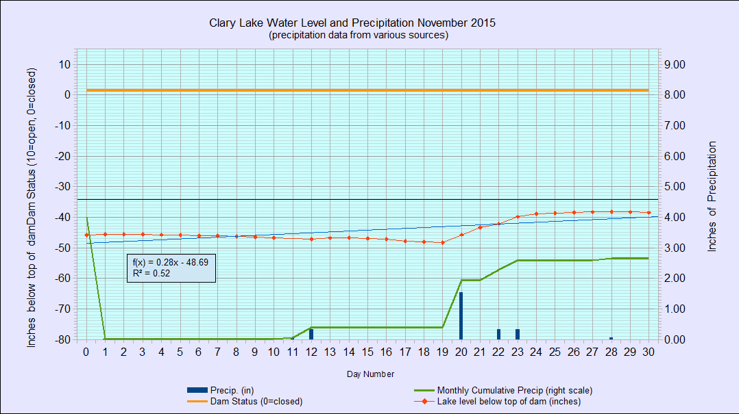
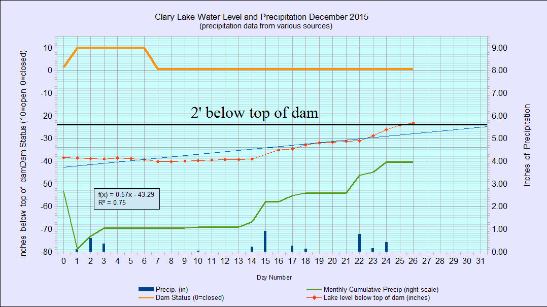
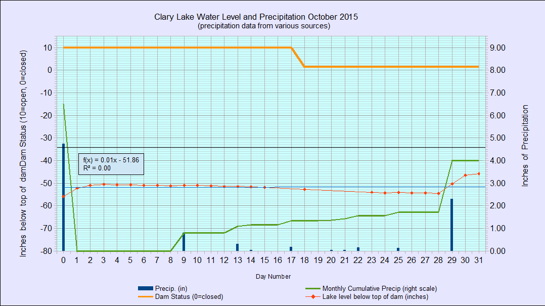
I’ve archived the November 2015 water level chart (at left). It is rather unremarkable, I suppose. The dam’s gate remains about 90% closed, or thereabouts. While we received enough rain during the month (2.66″) to bring the lake level up a total of 10.8″ it still fell 3.00″ (at the rate of about 1/4″ per day) over the course of the month because more water than required to supply the minimum flows is being released from the lake (see: Minimum Flows Explained). The net result was that the lake started out the month at 45.60″ below the top of the dam and ended up only 7.8″ higher, at -38.52″ below the top of the dam. While this is an improvement over the abysmal lake level we suffered with all summer, it is still way too low: the lake is currently almost a foot and a half lower than it really should be this time of year, going into freeze up.

DSC_0568DSC_0567
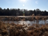
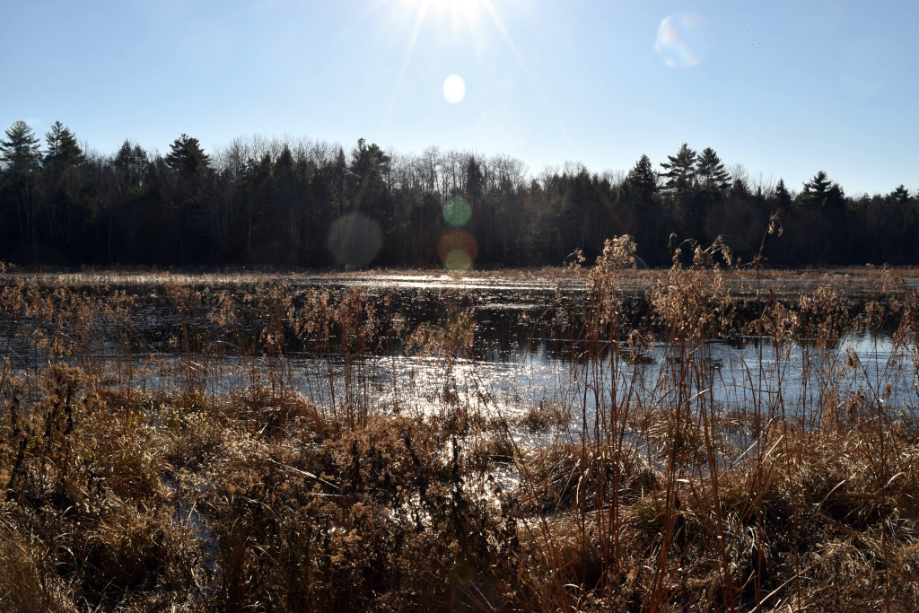
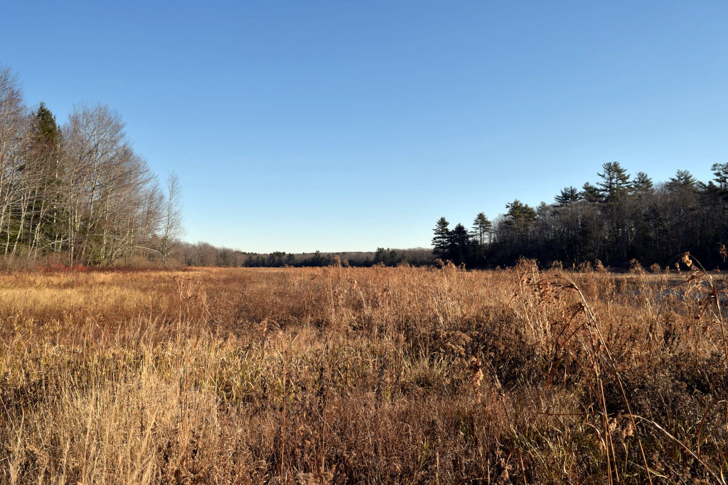
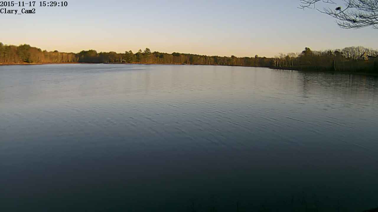
And that’s a pretty important foot and a half of water that is still missing, as the pictures at left will show. I took these yesterday. While the channel is now full and the water has overflowed the channel banks some, most of the 300 acres of wetland at the outlet end of Clary Lake is still high and dry.

The only good news to report I suppose is that after a very dry summer and fall, the runoff multiplier is back to something approaching normal (4X) indicating that ground water supplies have been largely replenished from recent rains. That said, we haven’t fully caught up yet. With only 32″ of precipitation to date, we’re still about 7″ below normal and I doubt in the next month we’ll reach the annual average of 44″ for our area.

25 November 2015: Full Moon rising over Clary Lake captured on Clary Cam2

moonrise-4I mentioned to David Hodsdon earlier today that tonight’s full moon was going to rise on a true azimuth of about 68.7° or about 10° to the left of the current edge of the field of view of Clary Cam2. David decided to adjust where the camera pointed this afternoon so as to capture the full moon rising. The picture at left is the result. The moon doesn’t rise in the same place each month. The point at which it crosses the horizon on it’s way up moves towards the north in the summer and fall and back towards the south in the winter and spring. By next June it will be rising over the State boat launch as seen from the location of Clary Cam2.

There are a few more pictures of this moon rise in the Webcam Picture Gallery. It’s possible that Venus, Mars, and Jupiter will be visible tomorrow morning about 4:30 AM. I won’t be up then but Clary Cam2 will start taking pictures at 4:00 AM. We’ll see what it captures.

17 November 2015: New Clary WebCam added to the site

Schedule_20151117-152910

Clary_Cam2

We now have a second web camera on Clary Lake! David Hodsdon decided he wanted to set up a web camera on his own shoreline so he bought one and today we got it hooked up and running. It’s identical to mine which made the back-end setup a breeze. The new camera is designated Clary Cam 2 (the original is Clary Cam 1) and it is attached to a tree on the shore about 150′ east of Hodsdon’s Point and it is looking directly towards the State boat launch which bears just about exactly East South East (114° True) from the camera. This means it will be capturing sunrises in the fall and spring as well as the occasional moon rise. Like the original camera, this one uploads a picture to the website every 2 minutes  from 4:00 AM until 9:58 PM every day and 7 days worth of images are stored in an archive that you can peruse with a browser.

I’ve made a new Clary Lake WebCams page that shows both current camera images side by side. You’ll find the page listed under the Pictures navigation menu heading. You can click on the pictures for full sized versions, or you can click on the Camera link at the top of each image and go to that camera’s own page.

Both cameras allow people to login to them to view remote, real-time video. See the individual Camera pages for Clary Cam 1 or Clary Cam 2 for instructions.

Meeting Reminder: Property Tax Abatement Information Meeting this Tuesday 11/17

[dropcap]Just[/dropcap] a quick reminder that the Whitefield Select Board will be holding an informational meeting at 6:00 PM this coming Tuesday November 17th for people who filed property tax abatement requests this past fall. The meeting will be held at the Whitefield Fire & Rescue building, Townhouse Road (map). This Select Board sent a letter last week to interested parties which was posted here (see below).

10 November 2015: Whitefield responds to Clary Lake shore owner abatement requests

[dropcap]The[/dropcap] Whitefield Select Board is sending the following letter to Clary Lake shore owners that filed property tax abatement forms recently. According to the letter, all the abatement requests were made too late to apply to the 2014/2015 tax year, a mistake I expect will be easy to remedy. It does appear that the Whitefield Board members are being proactive and showing concern and understanding for the situation faced by Clary Lake shore owners.

[pdf-embedder url=”https://clarylake.org/wp-content/uploads/2015/11/Whitefield_abatement_response_11-10-2015.pdf”]

05 November 2015: Whitefield Selectmen to Hold Meeting on Clary Lake Abatement Requests

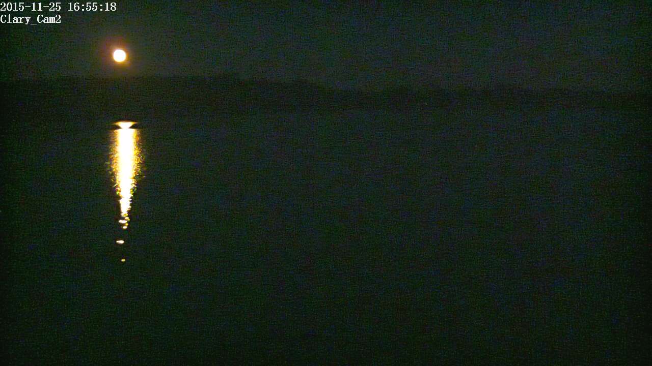
There is an article in this week’s Lincoln County News by staff reporter Abigail Adams about an informational meeting to be held by the Whitefield Selectmen for Clary Lake shore owners who filed property tax abatement requests this past fall due to the impact low lake levels have had on their property values. The meeting will be held on November 17th at the Select Board’s regularly scheduled Tuesday night board meeting. The article states that the aim of the meeting is to educate landowners about the town’s current valuation methods for waterfront property. Apparently some of the abatement requests were not considered because they were received after the deadline for filing them. Abatement requests have to be filed within 185 days of when the taxes are committed.

Assessor’s Agent Tom Hayes who is quite familiar with the water level issue plaguing lake shore owners stated that Whitefield’s valuation for shore front property is already “as low as it gets.” This is small consolation to property owners who can’t deploy their docks, launch their boats, go swimming, or otherwise use and enjoy the lake in the manner in which they have become accustomed. People trying to sell their property are finding it almost impossible because of the low water conditions on their shoreline. The low water conditions which have persisted more or less continuously for the last 4 years were especially worse this past summer due to the extremely dry conditions with the lake reaching levels lower than anyone can remember.

Continue reading

02 November 2015: New “Minimum Flows Explained” Page

Screen shot from the StreamStats program showing Clary Lake and the various streams making up the watershed.

Screen shot from the StreamStats program showing Clary Lake and the various streams making up the watershed.

I’ve been working on a page that explains minimum flows for a while now, and I guess it’s close enough to done for general consumption. I’ll update it from time to time as my understanding of this subject grows or new information becomes available. You’ll find the page under the Programs/Education main menu heading. Here’s a link to it:

Minimum Flows Explained

The picture at left is from the new USGS StreamStats hydrology mapping system, a really cool web-based application that lets you investigate watershed and stream flow data, from that small stream flowing through your back yard to the 145 square mile Sheepscot River drainage basin just like you knew what you were doing. I discuss the StreamStats program and how it might be used on the Minimum Flows Explained page.

Questions or comments are welcome. If anyone finds any errors or broken links please let me know.

31 October 2015: October 2015 Water Level Chart Archived

10 waterlevelchart_October2015[dropcap]I’ve[/dropcap] archived the October 2015 water level chart (at left). The most notable thing about it is that sometime during the weekend of October 17/18 the gate on the dam was almost completely closed. The gate had been wide open since October 13, 2012. The gate still remains open about 3″ or 4″ or so, presumably so as to provide the minimum outlet flows calculated for Clary Lake and required in the Clary Lake water level order (WLO). Regrettably, the gate opening still allowed too much water to be released as the lake level continued to fall albeit at a somewhat slower than usual rate: the lake level dropped 0.15′ (1.80″) over the next 10 days (0.18″ per day; normal for this water level would be 0.25″ per day) until the 29th when we received 2.3″ of rain in one intense 12 hour storm. That the lake continued to fall after the gate was lowered clearly indicates that outflows from the dam exceeded inflows into the lake by measurable amount, which means too much water was being released. In my copious spare time I’ve been working on a post about minimum flows but it’s not ready so I’m not going go into them now. Minimum flows are fully explained in the Department of Environmental Protection Rules, Chapter 587: IN-STREAM FLOWS AND LAKE AND POND WATER LEVELS. While that’s not an easy document to wade through, it makes for interesting reading and fully explains the the purpose of minimum flows.

[dropcap]At[/dropcap] 45.84″ below the top of the dam, the lake level is higher now than it’s been since May 21st of this year. As high it seems that is still more than 2′ lower than it should be this time of year (no more than 2′ below the top of the dam). The 2.3″ rainstorm on the 29th brought the lake level up 8.76″ for a runoff multiplier of 3.8x which is still a little low indicating that runoff is somewhat reduced because the ground is still relatively dry and a lot of the rain is soaking in rather than running off. Average yearly rainfall for our area is about 42″ and as of the end of October, we’ve received only 29.41″ or more than 12″ less than normal, and only 2 months to make up the difference. Unlikely.

[dropcap]I[/dropcap] hate taking my boat out and I usually put off hauling out in the fall as long as I can. I think however I will take advantage of this increased lake level and haul my boat out tomorrow.

30 October 2015: Grand Army Weather station back online

Tim Chase’s Grand Army Weather Station and Web Cam have been offline since sometime in 2013. Last month I helped Tim get his Web Cam  back up and running, and since then he’s been working at getting his new Grand Army Weather Station hardware set up, wired, and calibrated. Today we spent the afternoon working together and got his weather station updating his website again. We’ve got plans to give his site a face lift and add some additional functions and features later this winter. Stay tuned.

http://www.grandarmyweather.com/

The weather data is uploaded to the website every 30 minutes, 24 hours a day. It’s great to have a local weather station to refer to again, and I’ll probably use a some of the data on this site, and likely will start using the precipitation data on the Clary Lake water level charts


29 October 2015: Water Level Order Enforcement: Where to from here?

[dropcap]I’ve[/dropcap] received a lot of inquiries about the September 28th Notice of Violation (NOV) and the recently issued letter from the DEP  denying the dam owner’s request for a stay of enforcement, with everyone mostly wanting to know what’s next? Where does it go from here? My honest answer is I don’t know what’s next and I’d rather not engage in speculation. I have been pointing people at the Department of Environmental Protection’s Enforcement and Compliance web page for general information, and the Department’s “Non-Compliance Response Guidance” document for more a more detailed look at DEP’s enforcement options. One thing is perfectly clear: the DEP has come out swinging and has every intention of vigorously pursuing enforcement of the Clary Lake water level order.

24 October 2015: The DLWA, SVCA, HVNC, and SWLA Join Forces

[dropcap]The[/dropcap] Damariscotta Lake Watershed Association, the Hidden Valley Nature Center, the Sheepscot Valley Conservation Association, and the Sheepscot Wellspring Land Alliance have joined forces and formed a new organization, Midcoast Conservancy. Clary Lake is smack in the middle of the aggregate land area covered by this new organization. This alliance has been coming together slowly over the past year and it sounds like they’re now finalizing the transition. The following is from an announcement email I received from the HVNC a couple of days ago.

Displaying

Meet Midcoast Conservancy!

Our new name is just the beginning of an exciting period of transition

We listened to your input. We asked our supporters to weigh in on the new name of our merged organization and we received over 50 suggested names, nearly 400 responses to our survey, and nearly 200 helpful comments. Thank you! In addition we sought out help from marketing experts. All this pointed us back to Midcoast Conservancy! Continue reading

23 October 2015: DEP denies PPM, AQF request to stay enforcement action

[dropcap]In[/dropcap] a 5 page letter issued just yesterday, the Department of Environmental Protection has denied the request by PretiFlaherty lawyers that they stay their enforcement action. The request for the stay was made in response to the recently issued Notice of Violation (EIS #2015-006-L) and was made on behalf of Clary Lake dam owner Pleasant Pond Mill LLC (PPM) and Clary Mill owner Aquafortis Associates LLC (AQF, collectively Petitioners) by letter dated October 8th. The Department is standing firm on their decision to enforce the Clary Lake water level order (WLO) at this time, citing overwhelming evidence of violations by the dam owner. The letter mentioned a September 22nd site visit by Department staff at which time they noted among other things, extreme low water conditions, declining wetland habitat, and a useless State boat launch. The letter also mentions and cites concerns raised in the letter jointly written by Representative Deb Sanderson and Senator Chris Johnson, and in the letter from the Whitefield Select Board, both of which appear to have been carefully considered in the Department’s decision to take action at this time. Continue reading

22 October 2015 Lincoln County News: DEP Issues Notice of Violation of Clary Lake Water Level Order

[dropcap]A[/dropcap] number of newsworthy things have happened this week, and of course I’ve been away and unable to update the website in a timely fashion. I’ll get caught up as soon as I can. To start, there is a lengthy article in this week’s Lincoln County News by staff writer Abigail Adams about DEP’s September 28th Notice of Violation. The article also covers the October 8th response filed by PretiFlaherty attorneys for Pleasant Pond Mill LLC (PPM) and Aquafortis Associates LLC (AQF) requesting the Department stay (put on hold) their enforcement action, pending the outcome of the appeal of the Water Level Order (WLO) in Lincoln County Superior Court. Ms. Adams interviewed a number of people for the story and includes quotes from Paul Kelley, Richard Smith, PretiFlaherty litigator Tim Connolly, and DEP spokesperson David Madore. I was also interviewed for the article, and accurately quoted.

The article contains a couple of misstatements worth pointing out. First the article states: “AquaFortis Associates was named alongside Pleasant Pond Mill in the petition, however the water level order issued in January 2014 only named Pleasant Pond Mill.” In fact,  Aquafortis Associates was both named in the petition AND, along with PPM, as a party subject to the final Water Level Order. Continue reading

18 October 2015 Kennebec Journal: DEP issues violation notice on Clary Lake water level

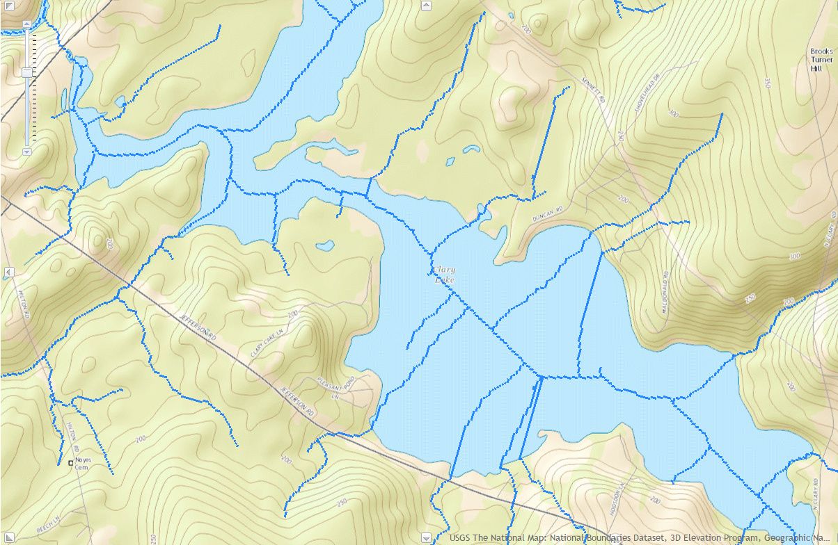
[dropcap]There[/dropcap] is an article in today’s Kennebec Journal (and Morning Sentinel) by Central Maine Papers staff writer Jessica Lowell about the Notice of Violation issued by the Department of Environmental Protection on September 28th (see: DEP takes enforcement action, issues a Notice of Violation). The article is factually accurate and lists the specific violations in the NOV, namely:

  1. failing to meet the 2014 water level order;
  2. failing to submit a surveyed plan showing the normal high-water mark of Clary Lake;
  3. failing to obtain DEP approval for a final water level management plan;
  4. failing to install a lake gauge and file a report detailing the inspection results of its installation;
  5. and failing to allow the lake to rise gradually between ice-out in 2015 until Aug. 1;

The article also states that Attorneys for Pleasant Pond Mill LLC (PPM) and Aquafortis Associates LLC (AQF) contend that among other issues, complying with the notice of violation is impossible because it sets deadlines that cannot be met, noting that PPM has only 15 days to comply with the minimum flow provisions of the water level order and to “undertake all other steps necessary to prevent further dewatering of the lake and begin raising the level of the lake in compliance with the (water level order).

I’ll post a link to an archived copy shortly.

13 October 2015: DEP takes enforcement action, issues a Notice of Violation

At long last, the Maine Department of Environmental Protection has taken decisive action by issuing a Notice of Violation (EIS #2015-006-L) to  Pleasant Pond Mill LLC (PPM, as the record owner of the Clary Lake dam), Paul A. Kelley, Jr., as former manager and sole member of PPM, Aquafortis Associates, LLC (AQF, as an entity asserting flowage rights), and Richard L. Smith, as manager and sole member of AQF. The Notice of Violation (NOV), issued on September 28, 2015, alleges that each day since at least October 1, 2014 constitutes a violation of the Water Level Order (WLO) and a separate offense. In addition to the NOV, the Department “retains its right to enforce its water level order by any other appropriate remedy, including, but not limited to, entering the dam premises to carry out the terms of the water level order.”  Continue reading