Some of you will remember seeing a table something like this last year, on the old site:
| Inches Below Top of Dam | Rate of Fall in 24 Hours |
| 0″ to 36″ | 1″ |
| 36″ to 48″ | 3/4″ |
| 48″ to 62″ | 1/2″ |
| Below 62″ | 1/4″ or less |
These figures were derived empirically which simply means these are based on measurements we made and recorded. They are what they are. They’re averages and on any given day they will likely vary a little or (even a lot) due to changing conditions: lake surface area, the shape of the lake, and most important, the amount of runoff from rain or snow melt. But all things being equal, these numbers should be pretty close most of the time.
Which brings me to the reason for this post: the question of how low can the lake get. I have in the past come to the conclusion that the rock-bottom low water level was 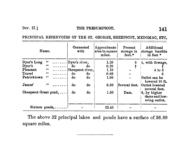 somewhere around 6 feet (-72″) below the top of the dam. This figure was arrived at after measuring the water depth at the mouth of the channel at the northwest end of the lake. I also came across a fascinating book entitled “The Water Power of Maine” by Walter Wells, first published in 1869. In it I found a table that I’ve reproduced the table at left. It estimates the additional storage in Pleasant Pond (now Clary Lake) as 4 to 6 feet. Coincidence? I don’t think so.
Yesterday afternoon Colin Caissie and I went over to look a the narrow gauge rail road abutments to assess their suitability for the construction of a coffer dam. To get the 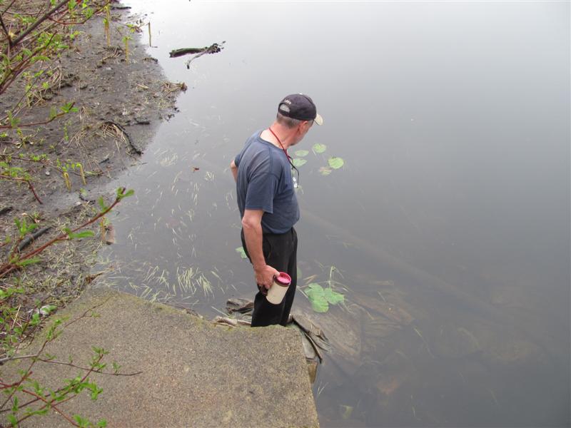 distance between the abutments, I waded across the channel (and filled my boots in the process) while dragging a tape measure and found the center of the channel to be 2′ deep. The water level at the time was -54″ below the top of the dam. Adding 24″ to this gives you an elevation of the center of the channel between the abutments of -78″ or -6.5 feet below the top of the dam. The average distance between the abutments by the way is 16.5′. There are more pictures from this adventure in the Spring 2013 gallery.
And there you have it folks. The lake can’t possibly fall more than 6.5′ below the top of the dam and chances are, since there is a gentle slope to the channel on the order of about 1/2 a foot over it’s entire length, the limiting factor likely is the elevation at the entrance of the channel. So if anyone asks you how far the lake can fall, tell `em “6 feet.”
The lake is down -54″ now. It can fall another 18″. Last spring it reached -63″ below the top of the dam. At the rate the lake is dropping, we’ll get there again in 10 days.
One conclusion we can reach from that book “The Water Power of Maine” is that in 1869, there was no dam on the pond. Pleasant Pond only had the potential of storing 4′ to 6′ of water, it wasn’t actually storing it. In the late 1700s there was a dam on the river side of the road, still visible today but I’d always thought there was a dam on the pond in the 1800s before Henry Clary came along in 1890-something but now I’m not too sure. The existing dam on Clary Lake may well be the first dam ever built on the pond.
Thanks for the pictures George. It is hard to believe it can get lower since I’m only seeing a mud puddle from the road at the dam. Something to be proud of for the dam owner, and to what end?