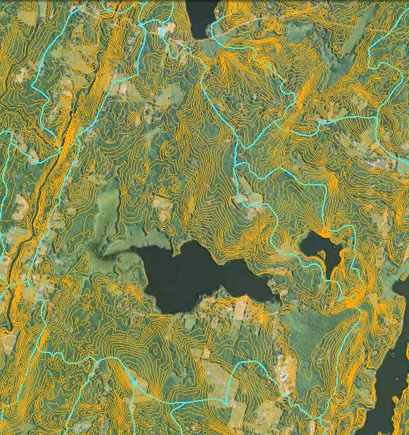
 I’ve put together a Clary Lake Watershed Survey Base Map using Google Maps and watershed boundaries from the Maine Office of GIS for Clary Lake and Three Corner Pond. The map is basically a proof of concept effort, and a work in progress to boot as I’m still learning how to fit all the pieces together. The next step will be to put the 90 or so records of NPS (non-point-source) pollution sites from the original 2001 watershed survey into a database, geo-reference them with latitude and longitude, add pictures and updated information where necessary, and then finally, import them into the map. The final product will be a simple but functional Geographic Information System (GIS) providing a convenient and easy to use map that you can zoom and pan around on with icons you can click to find out the particulars of any given NPS pollution site- where it is, who owns the property, what type of NPS site it is, what was done to mitigate the pollution, when, by whom, how much it cost, etc. These site can then be revisited to see how they’re fairing after 12 years.
Another aspect of the project will be to resurvey the watershed to locate new, as yet un-cataloged NPS pollution sites and enter them into the system. Once all the NPS sites have been identified, cataloged, and prioritized, we can get to work on designing and implementing erosion control measures or other pollution control measures depending on the site. Grant money is available from the State to help with this work.
For now the Clary Lake Watershed Survey Base Map is linked in under the Charts & Data main menu heading. It will likely have a sub menu all it’s own, in due time.
It’s likely this project will languish due to lack of attention for a while as it’s a low-priority project and there are other more pressing things to work on. I’ll try to keep a low fire going under it.