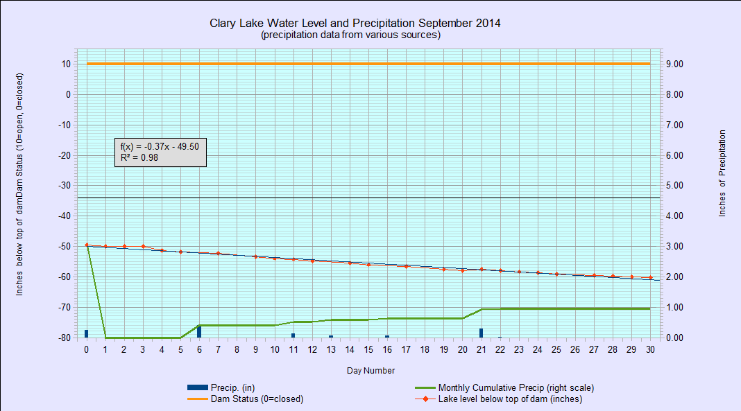
 I’ve just archived the September 2014 water level chart… and what a month it was. The effect of only having received 0.95″ of rain for the whole month (average is 3.74″) is painfully evident in the slowly but steadily declining water level over the course of the month. The water level is currently 60.24″ below the top of the dam. It can fall further, but not a whole lot further: an examination of the data used to create the chart shows that the rate at which the lake is falling is dropping off fairly quickly. At the beginning of the month it was falling between almost 3/4″ per day. Now, at the end of the month, it is falling about 1/4″ per day. At that rate, it won’t take much rain at all to offset the drop and the lake will bottom out, and stop falling. Last Friday Tim Harkins told me that he’d tried to get up into the meadow in his kayak but was unable to find the channel.
The likely explanation for the situation Tim encountered is that low water conditions combined with ice over the past couple of winters have caused the bottom sediments in the vicinity of the outlet to be pushed up forming a bar of sediment and that this bar is blocking the outlet channel, impeding the flow of water out of the lake and limiting how low the lake get get. This same mechanism- ice pushing against the lake bottom over time- is likely what created the sand bar that can be seen down by the State boat launch. In that case, there was enough water flowing into the lake to cut a channel through the sand bar. It remains to be seen if there’s enough water flowing out of the lake to do the same thing. I doubt it.
Two years ago the lake got down to 63.25″ below the top of the dam. Realistically I don’t think it can fall that low again, but I might be wrong. In any case I intend to go out and try to find the channel myself, later this week. Stay tuned.