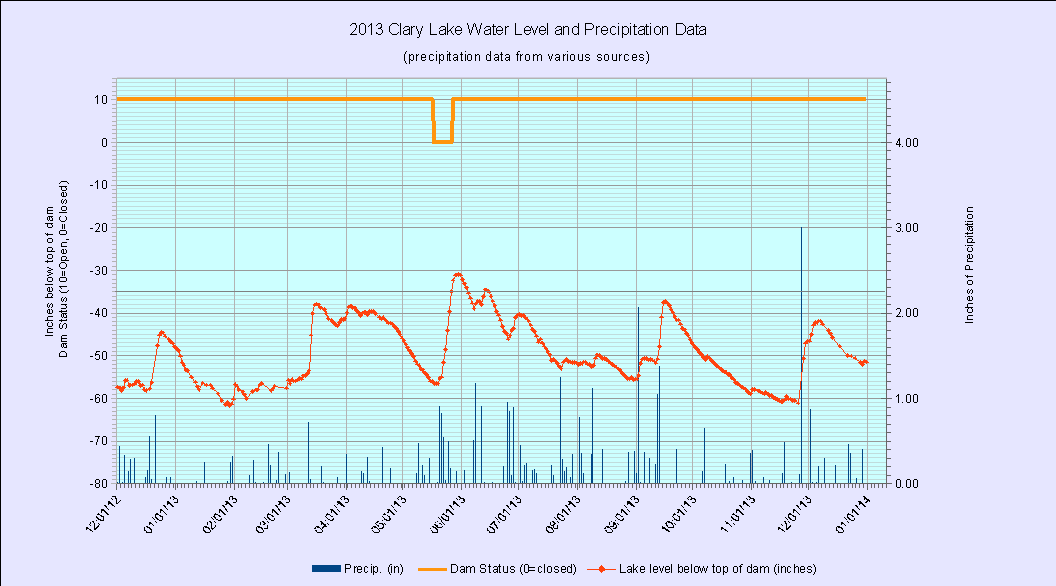
 Happy New Year everyone! It is the beginning of another year and I’ve posted the 2013 water level chart (at left) to the Archived 2013 Water Level Charts page. For some reason I can’t fathom (pun intended) the water level charts are not the most popular items on the web site, in fact only 2 people check them out with any regularity, David Hodsdon and Paul Kelley. David’s interest stems from having a scientific bent to begin with coupled with having measured the water level of Clary Lake off and on for the better part 30 years, and he just likes to admire a pretty chart. I suppose Paul has his own reasons for paying such close attention to the lake level. Perhaps he too just enjoys a pretty chart.
Initially I started measuring the water level of the lake to document the water level fluctuation and assess it’s impact on the environs of Clary Lake, to be used as evidence in support of our petition initiative. As with David, I also happen to have a scientific inclination as well as the technical skills and professional experience required so it has also served as a form of entertainment. Call me crazy. Since starting measuring the lake level however, it has become more of a ritual, something that I do with a measure of solemnity though it’s challenging to keep it up on a regular schedule during the winter due to the complications of snow and ice. It remains to be seen if I will continue with the practice once the Water Level Order goes into effect and water level measurements are being made at the dam; I expect I will at least initially because I want to investigate further the dynamics of runoff, water flow, and their effect on the elevation difference between the lake surface and the water level at the dam.
Some 2013 Statistics:
There are lots of ways to slice and dice the volume of data I’ve collected. Here are a few statistics for the past year. If anyone is interested in the raw data, just ask.
- We started the year at -48.36″ below the top of the dam and ended slightly lower at -51.48″ below the top of the dam.
- We received 40.23″ of precipitation in 2013 compared to 39.98″ for 2012, only 1/4″ difference.
- The highest water level we saw in 2013 was -31″ on May 30th and the lowest was recorded on January 29th when it reached -61.68″ below the top of the dam. For comparison, in 2012 the highest was -19.08″ on June 7th and the lowest was -62.52″ on April 21th.
- The average water level in 2013 was -48.9″ below the top of the dam compared to -45.7″ below the top of the dam in 2012.
- In 2013, the dam’s gate was closed for only 10 days, from May 17th to May 26th during which time we received 4.33″ of rain which brought the lake up 25.56″ to -31″ below the top of the dam by May 30th, the highest the lake would get in 2013.
- In 2013 the depth of water over the foot of the State boat launch was equal to or greater than the design value of 2.3′ for only 7 days during the last week of May.
Archived 2013 Water Level Charts


The water level variations are of great interest to me. I often wonder what the lake condition was like before the dam was put in. Anyway, thanks George for maintaining the water level records.