February 2018
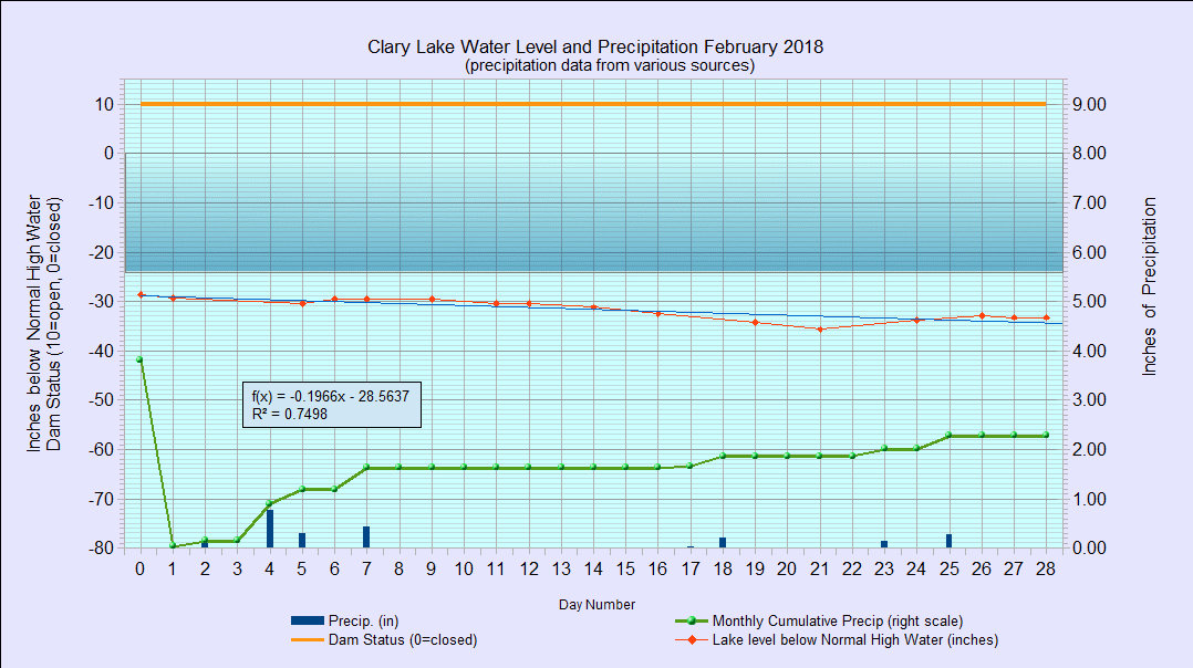
I have archived the February 2018 Water Level Chart (at left). The most notable feature of the February chart is how little the lake level changed over the course of the month despite the gate being wide open and with no major precipitation events to generate runoff. We started the month at -29.28″ below the normal high water mark and ended the month at -33.24″ below the normal high water mark, only 3.96″ lower that we started. The lake level was also above the hole in the dam for the whole month, increasing the amount of water leaving the lake. Nonetheless, the lake level stayed pretty flat for the month; I attribute the relatively stable lake level to reduced outflows as a result of channel friction and ice cover in the marsh which has been unusually thick this winter. Precipitation for the month was 2.28″ which is a little less than the historical average of 2.44″ for the month of February. Year to date our precipitation total is 6.09″ which is an inch more than average.
Hi George,
I’m working on the Lake and Streambed Alteration Program in Maryland. Just wanted to ask about the two images which could be compared. Could you please share them with me? I see that it’s a gif format of the chart. I’m currently comparing the results of two months of Deep Creek Lake. But I’d be grateful for the info on February you’ve got. Need to see the changes and the probable dependence.
Thanks,
Ray (my Facebook – razor331)