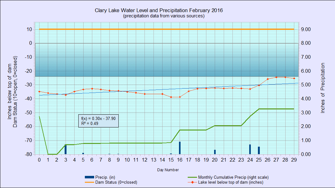
 I’ve archived the February 2016 Water Level Chart (at left). The most notable feature is that the lake level stayed in a fairly narrow range around an average of -34.5″ belog the top of the dam, for all but the last 5 days of the month when the level rose to within touching distance of where it should be this time of the year, around -24″ below the top of the dam. This was by chance and not design because the gate has remained wide open since January 4th.
Another factor contributing to a (relatively) stable lake level is that between precipitation events, the lake level dropped an average of only 0.6″ per day, considerably less than the 1″ per day we would expect. This is likely due to frozen ground and warmer than usual winter weather resulting in increased snow melt and runoff. Recall this table which I first compiled back in 2012:
| Lake level in inches below top of dam | Rate of fall in inches in 24 hours |
|---|---|
| 0" to 36" | 1" |
| 36" to 48" | 3/4" |
| 48" to 62" | 1/2" |
| Below 62" | 1/4" or less |
We received a total of 3.26″ of precipitation in February or 0.82″ more than the average of 2.44″ for the month. Most of the precipitation was in the form of rain and/or ice. If it had all been snow we’d be in record territory but as it is, snowfall for the 2016 winter is well below average. This is likely attributable to the El Niño phenomena that is affecting everyone’s weather this year. The lack of significant snow pack does not bode well for spring runoff and lake levels this coming spring.