Category Archives: Editorial

George’s Editorial Comments.

08 June 2013: A few thoughts on Kelley’s recent vitriolic response to Procedural Order 6

angry_business_manAfter having his request for an extension denied, I expected Paul Kelley to take things to another level but I did not expect him to lash out with an angry, hate-filled, indiscriminate attack against anyone and everyone. Nobody is above ridicule or scorn. Clearly, Kelley is losing this battle and he knows it, and this latest tirade is proof of that. For those of you who haven’t figured out what his response was all about, he’s appealing the Presiding Officer’s decision denying him an extension to the DEP Commissioner. That intent was contained in the last cryptic sentence on the very last page (the reference to 06-096 Chapter 3 refers to the Department of Environmental Protection’s rules concerning the conduct of licensing hearings, with section 4(D) being ruling appeals). The rest of the document is Kelley going postal: pure and simple spiteful vitriol or as the saying goes, “shock and awe”. That’s sure going to go over well with the Department. Not.

In his anger Kelly perhaps revealed a few things that a calmer, more cautious Paul Kelley would not have said. For example, I have suspected for a while now that his plan with the petition for release from dam ownership or water level maintenance (which he prefers to call “Clary Lake Dam abandonment proceedings”) was to try and stall the water level petition long enough to get a breach order from the State but of course he couldn’t come right out and say that because that’s not the purpose of the statute. He has to pretend he is looking for a new dam owner because to do otherwise would be to engage the State’s resources under false pretenses and make a mockery out of the system. Well he came right out and said in his response what the real deal with the petition for release from dam ownership is about, in footnote 6:

…”that the anomalies cited herein and in previous filings have largely triggered recent Clary Lake Dam abandonment proceedings by PPM – proceedings seemingly likely to lead to a formal (but superfluous) breach order by the Commissioner, which will supercede any Water Level Order which may issue from this proceeding.”

Caught in the act of playing both sides against the middle. Nice work Kelley, thanks for putting that bit on the record. DEP just loves to be played for a fool. Your chances of actually getting a breach order on the dam? Zero. Watching you try? Priceless.

I have a few other observations I’ll keep to myself for now. I have no intention at this time commenting on this response. There are several issues he’s raised (over and over and over) which will be adequately dealt with when we prepare our Findings of Fact. The DEP has their hands full for the time being. I see no sense in adding to the furor at this time.

07 June 2013: It’s Comment Deadline Friday :)

mema-customToday is the deadline for submission of comments on the material distributed as an addendum to Procedural Order 5 back on 9 April. Comments were originally due on 9 May but on 7 May, DEP granted Paul Kelley a 30 day extension. Kelley requested another 30+ day extension late last week. That request was denied.

There were two documents distributed with the addendum, the new minimum flows recommendation “Clary Lake Assessment” and Maine Emergency Management Agency (MEMA) comments. Theoretically comments due today could be on either document, but Kelley and I have already submitted comments on the minimum flows recommendation so this deadline is all about Dam Safety.

Kelley would appear to be having an apoplectic fit around the issue of dam safety. From his second appeal to DEP for an extension to the comment period:

“The DEP’s post-hearing actions seem to indicate that the department is apparently contemplating using unchallenged “data” to a) impose not only a new definition of “normal high water”, but b) to do so in an effort to impose a Water Level Order impounding in excess of three quarters of a BILLION gallons of water behind an uninsurable, 110 year old breached dam, and pointing it, like a loaded gun, at a federally designated National Register property AND a federally designated Endangered Species spawning ground directly downstream.”

A bit overly dramatic, don’t you think? And the real irony? That Kelley owns that “loaded gun” 🙂 And Kelley expects us to believe he doesn’t have an interest in that “federally designated National Register property” and even more laughable, that he actually cares about a “federally designated Endangered Species spawning ground.” What does he think we are- stupid?

For my part, I had not intended to prepare any comments on the MEMA report because I couldn’t think of anything to say. However, since Kelley is making such a big deal about it, I feel I must say *something* so I’m working on a short set of remarks. In the mean time, I wait with anticipation for Kelley to submit his tirade on dam safety and his indictment of MEMA for failing to take the safety of the Clary Lake dam and the high-water risk to his downstream property seriously. It’s sure to be a “classic Kelley” tirade.

28 April 2013 Commentary: Spring is finally here.

campic_hammockIt seems like this April has been colder than usual, certainly colder than it had to be though that is just my opinion. Most everyone I’ve talked to seems to agree with me though. Anyways, it just seems like it hated to warm up this month and this in spite of the lack of rain. I usually think of April as a cold and wet month, but this one was just cold. We’ve only received 1.58″ of rain so far, well below normal. In the past couple of days though the weather sure has taken a turn for the better and it looks like we’re in for a good stretch of warm, dry weather. People are out fishing, putting docks in, and cleaning up around their yards. It’s nice to see activity around the lake again. I for one constructed a slip for my boat and hung my hammock today. I was somewhat chagrined to see that the hammock (and anyone laying in it) it is visible on the webcam. Not sure how I feel about that.

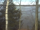
shallow_waterThe lake was like a mirror this morning and the sun was bright. I was sitting down by the lake having my coffee and contemplating where we’ve been with this water level petition so far, and where we’re headed. And of course, I couldn’t help but notice how bloody shallow the water is on my shoreline. The picture at left tells the story. The water level is currently 44.25″ below the top of the dam and falling about 3/4″ a day. 25′ off shore the water is less than 2′ deep, and that’s about as close as I can get to shore with my boat without pulling the motor up and rowing. Everyone around the lake is in the same boat. As it were. More or less. Some have more water, some have less.

chick-on-mothers-back-claI was looking through an old Association photo archive the other day I and came across 4 pictures of loons with a baby. The pictures are dated July 14, 2003 which is very likely the last time we had a baby loon on the lake. If anyone knows who took them, please let me know so I can give them credit. I’ve added the pictures to the User Uploads Gallery. Let’s hope the pair of loons on Clary Lake this spring have more luck nesting than they did last year. They need a stable water level. It doesn’t look like they’re going to get that this year.

The week ahead promises to be action packed with something happening it seems like every day. Tomorrow there are 3 letters going in the mail. As soon as they have been mailed (and emailed) to their intended recipients, I’ll post them on the web site. Tuesday night is Whitefield’s Information Public Meeting, 7 PM at the Whitefield Fire & Rescue building on Town House road. Wednesday we get the Department’s responses to my and Paul Kelley’s comments on the bathymetric survey. That should be interesting.

Thursday I’m going fishing.

I am more firmly committed to resolving this Clary Lake water level crisis now than I have ever been. I’m not tired, nor disappointed with where we are in the process. I believe DEP is acting with the best of intentions and with the importance of Clary Lake’s valuable wetland habitat, and the best interests of the general public firmly before them. While the situation is still fluid and somewhat confusing with the 2 different petitions underway, I see a path forward through the confusion and I am more confident of the ultimate outcome now than ever before.

21 April 2013: Howard Nickerson: What price are we willing to pay?

red-winged-blackbird-thumbI was visiting Jane Chase this morning and she happened to mention an impassioned letter to the editor of the Lincoln County News that she’d read recently that did not ring a bell with me. Sadly, as much as I try and stay on top of everything going on these days, I just can’t and I rely heavily on other people to let me know about things of importance to Clary Lake and the water level petition. Jane found a copy on line and sent it to me. The letter to the editor turned out to be by none other than my good friend Howard Nickerson and was sent to the paper back in the middle of March. My apologies for just now getting it posted.
What price are we willing to pay?

Howard owns land up in the northeast end of the marsh on the east side of Clark’s Meadow Brook adjoining land of Sue McKeen and Butch Duncan. He’s a life-long conservationist.

17 April 2013: Post followup thoughts on Petitioners Comments on the bathymetric survey

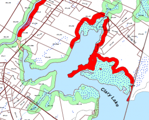
I kinda wish I’d thought to include this section of the Whitefield Shoreland  Zoning Map produced by the Sheepscot Valley Conservation Association in my Comments to DEP on the bathymetric survey. It clearly shows as all the wetlands that the State left off their plan. The legend refers to those greenish blue areas with the blue dots as “Wetlands in Shoreland Zone (NWI)” which I assume refers to the National Wetlands Inventory, which I cited (numerous time) in my comments. So I guess it’s covered. On the other side of the coin, you can see why Butch Duncan is a little irritated: that bright red boundary along his property is a Resource Protection Zone. Of course, that same Resource Protection Zone bounds all of Howard Nickerson’s property, all of Sue McKeen’s property and her daughter’s property, all of the Mathews, Shorey, and Weeks properties, and a little bit of the next lot south (Roever?) and we don’t hear them grousing about the water level being too high and arguing for the removal of the dam.

13 April 2013: Fergusson’s Letter to the Editor in response to the Duncan article

Things have been so busy around here that I never bothered to look at the letter to the editor I wrote in regard the article about Frederick Duncan and his water level wishes. I sent my letter in back on the 1st of April. It appeared in the 04 April 2013 edition of the Lincoln County News. From the For What It’s Worth department, here it is:

Fergusson’s Letter to the Editor

09 April 2013: Thoughts on the new Minimum Flows Recommendation

The new Minimum Flows Recommendation (see Clary Lake Assessment 3-Apr-13) gives me pause for thought.

First, I’m not quite sure how they came up with this- it appears to be based in large part upon section 6 of Chapter 587, the Standard Allowable Alteration method of determining required water levels in Class GPA (Great Pond Act) waters which however discriminates between a 1′ draw down from April 1st through July 31st and another 1′ draw down (for a total of 2′) between August 1st and March 31st as opposed to a total maximum draw down of 2′.

Second, the document quotes some numbers from the bathymetric survey (the figures 17% of the total lake volume and 14% of the total lake surface area come directly from the data table) but does not arrive at a draw down corresponding to the 25% volume reduction or the 25% area reduction. I’m not complaining, but why? Are they perhaps aware of problems with the modeling of the wetland area?

Third, and I’ve already mentioned this in response to David Hodsdon’s comment on another post, they suggest that the figures they’ve come up with are ONLY intended to protect the main basin of the lake:

Recommended within basin water levels are protective for the maintenance of suitable Water quality, resident fish and Wildlife habitat, and prevention of shoreline erosion. However, it is quite apparent that significant dewatering of valuable Wetland habitat will result in the vicinity of the outlet stream, above the dam.

What’s up with that? One can’t lower the water level in the basin without also lowering the water level in the marsh. How can a 2′ draw down be protective of water quality, resident fish and Wildlife habitat, etc., and yet contribute to “significant dewatering of valuable wetland habitat”?

This sentence is a new addition to the minimum flows recommendation they prepared a year ago.

Fourth and finally, they list minimum outflows which must be met unless inflows are less. How are we supposed to measure inflows? I assume if you’re letting water out and the lake is not falling, then inflows equal outflows. If you’re letting water out and the lake is falling, then outflows are greater than inflows. Finally, if you’re letting water out and the lake is rising, you’re not letting out enough water. This hit-or-miss approach seems amateurish and error prone. Surely there is a better way!

There is: We install a top weir in the dam with stop logs at some level such as 12″ below the top of the dam and walk away and let mother nature take care of it. I wonder what they’ll think of such a plan.

It is also interesting to note that the minimum flow figures are identical to those published a year ago.

Filed under Petition News and Technical Lake Stuff with a hint of Editorial.

03 April 2013: FOA Request, Preliminary Survey Reaction, odds and ends and end of the day wrap up.

Well it’s been quite a day- a couple of days actually, a lot of activity all of a sudden. Of course, it’s not quite 3pm so it’s entirely likely that something else will land in my lap before dark. Anyways, there are a few things I want to pass on before I forget. First, I received an email from DEP this morning about a FOA request:

The Department of Environmental Protection has received a Freedom of Access Request regarding communications between Department staff and individuals associated with the Clary Lake Level Petition. The records responsive to this request will be available by the end of this week. If you are interested in reviewing the documents, you may make an appointment with the Department’s File Room by calling 207-287-7843.

One has to wonder why, if Pleasant Pond Mill LLC is committed to being relieved of dam ownership, why are they bothering with an FOA request? Perhaps they are just hedging their bets, looking for ways to shoot down our petition. This doesn’t mean they’re not seriously pursuing their own petition for release from dam ownership, does it?

Bathymetric Survey

I have not really had the time to go over the bathymetric survey in detail but my initial reaction is that it is somewhat flawed. More about this when I’ve had a chance to go over the survey and data in detail and have been able to discuss it with some other people.

Ice Out?

 On a lighter note, the ice shelf hugging my shoreline this afternoon finally succumbed to wind and wave action, breaking up and floating away a little over an hour ago. And then just a bit ago a long thin slab of ice drifted in from some place and settled in against my shoreline. It has already broken up and floated away as I type. The only ice left is a bunch of slush that has washed up down at the far east end of the lake. From other reports I’ve gotten from others around the lake and what I’m seeing out side my window now, David Hodsdon will be hard pressed not to call ice out today, 03 April, 2013.

User Picture Submissions

Finally to wrap up this post, Trudi Hodgkins sent along a couple of recent pictures which I have posted in the User Uploads- Clary Images gallery. They should be showing up auto-magically in the “Recent Pictures” box in the side bar as the gallery default sort is by date, descending i.e., newest pictures at the front (or top?) of the gallery. And here, to the left and the right, are the thumbnails. So you don’t have to hunt around for them. Thanks Trudi!

I’m done.

30 March 2013: A lot like spring out there today, and other thoughts

Gorgeous day out there today, I’d say most of the north side of the lake is ice-free, perhaps about 1/4 of the lake total- enough so that open water is now easily visible on the web cam from over here on the south shore.

 David Hodson and I stopped over yesterday afternoon take a look around and bumped into Doug Kinney. He said there’d been a pair of loons hanging around. Sure enough, we soon spotted one loon but it was too far off for me to get a picture. It is the earliest I’ve ever seen loons back on the lake. There were also plenty of other water fowl out swimming or wheeling overhead. At the rate ice is disappearing, I expect the lake will be ice-free within a week. Lousy weather could complicate that.

I’d like to thank those of you who corresponded with me about the recent article in the Lincoln County News. No, I don’t think Butch’s plan to have the dam removed stands a chance of happening; it’s just silly, as is his idea of “farming” the meadow. In the old days folks likely pastured some cows out there part of the year when it wasn’t flooded, and we know they cut meadow hay during a short window of opportunity in the early summer, but that’s about the extent of the “farming” that took place in Clark’s Meadow. We all know why Butch would like the water level kept low- his reasons are purely selfish. I will be sending a letter to the editor next week.

Some of you may have noticed that I went ahead and converted all the old legacy photo albums to new WordPress NextGen albums. I hadn’t planned on doing that but it turned out to be pretty easy. They offer more utility and convenience and do a better job of displaying pictures. Sadly, they don’t handle documents like PDF files of which there are a boatload on the site. I’ll have to look for another solution to manage and maintain those.

Finally, I stopped by the dam this afternoon to measure the outflow from the lake; came up with a figure of 35 cubic feet per second which is about what is expected with the lake level 40″± below the top of the dam. Have been wondering if there’s a way to estimate Clary outflows with any degree of accuracy using flow data from the USGS Sheepscot river gauging station located at the bottom of Grand Army Hill. More on this when I find some spare time.

Reminder: This coming Wednesday the 3rd DEP is supposed to distribute the results of the bathymetric survey they performed last September. Stay tuned 🙂

28 March 2013: Fergusson Response to recent Lincoln County News Article

I don’t have a lot to say about Frederick Duncan and his position on the Clary lake water level but I did want to respond to the article, before I move on. I like Butch and I respect his right to his opinion. As long as I’ve known him he’s been an advocate for lower water levels because of the impact that high water levels have on his use and enjoyment of his land. I understand. The 250′ shoreland zone infringes on his wood lot and limits what he can cut. Also, with parts of his property being in a resource protection district and adjoining mapped emergent wetlands and significant water fowl and wading bird habitat, he is further limited in what he can do with his property. I understand that too, and I acknowledge the fundamental unfairness of it while at the same time I welcome the protections afforded by these laws- laws intended to protect and safeguard valuable natural resources held in trust for all the people of the State of Maine.
 
Perhaps it is just too bad for him that he owns some of the most beautiful, sensitive, and vulnerable wildlife and wetland habitat on Clary Lake. As a fellow Clary lake shore owner with quite a bit of shore front property of my own, I am sympathetic to his plight: all of us who own land on or directly adjoining Clary lake have found that over the years our property rights have been increasingly limited by newer and more restrictive environmental and shoreland zoning regulations. We can’t cut the trees we might like to cut, we can’t build on our property where we’d necessarily like to build. But these regulations are intended to safeguard Clary lake and it’s associated wetland and wildlife habitat, and I have come to terms with their impact on my property rights. I am but a steward of my property which I hold in trust for future generations. I think the sooner Butch comes to terms with the reality of the situation and stops fighting a losing battle, the better off he’s going to be, because the Clary lake dam isn’t going away and the State isn’t going to let him drain wading bird habitat so he can plow up Clark’s Meadow.

16 March 2013: Ruminations on a Water Level Regime

The rapid rise of the water level of Clary Lake from -54″ below the top of the dam to -38″, a rise of over 16″ in just 3 days from only 3/4″ of rain and a little snow melt perfectly illustrates why Paul Kelley’s plan to “manage” the lake’s water level is both ill-conceived and fatally flawed. Kelley would like to maintain the lake at a low enough level so he can capture any conceivable amount of rain and runoff without it over-topping the dam. He could then release the water at a rate that wouldn’t overload the ability of the mill pond on the west side of the road to handle the discharge. According to Kelley, the mill pond can only pass 55 cubic feet per second of flow from Clary Lake without flooding his building and causing damage to the foundation. Kelley is currently doubly confounded because of the hole in the dam: he’s not just trying to keep the lake from over-topping the dam, he’s trying to keep it from getting within 3 feet of it. The water is already within inches of reaching the hole. He’s playing a very dangerous game.

If Kelley really wants to protect his mill building from high water damage, perhaps he should follow the advice in his own bought-and-paid-for URS engineering report and re-install the original overflow weir in the lower mill pond and not try to manage the outflow from Clary Lake over which he has no real control.

Clearly, if the lake can rise 16″ from what can only be characterized as a very small spring rain storm with a minimal snow pack, how much could it rise from a large spring rain storm when there’s a deep snow pack with saturated ground? We may get a chance to find out sooner rather than later: predictions for this coming Tuesday are for a wet spring snow storm and depending on which model you use could drop 15″ of heavy snow on us (the European model) or 4″-8″ of mixed snow, sleet, and freezing rain (GFS, or Global Forecast System model). The difference between the models is one of temperature; the European model forecasts a colder storm with snow throughout the region whereas the GFS model forecasts a warmer storm with snow inland and more rain and sleet towards the coast.